The History of the Mill
Historically Mickle Trafford, also known as Magna Trafford or Great Trafford, lay in the hundred of Broxton. After the Norman Conquest this area belonged to the Fitzalan family. The township presumably remained undeveloped in the early medieval period due to its low lying land. It would appear the word Mickle came from the Latin Magna and the Old Norse Mikill (meaning much). Trafford Mill was not recorded in the Domesday Survey, indicating it was not in existence during the Anglo Saxon Period.
Throughout the 14th century, the land which included a mill, was part of the estate of the Earl of Chester, who leased it to various tenants. The earliest known reference to the Mill is in 1302/03, when the Cheshire Chamberlain’s Accounts state that Richard the Engineer leased Trafford Mill together with lands and common pasture. A survey undertaken by the Midland Wind and Water Mills Group in 2003 indicated that the current mill building to the north is built on the sandstone foundations of the medieval mill.
William Troutbeck took over the Mill in 1416 and remained in possession of the property until 1510 when the inheritance passed to the Talbots who later became the Earls of Shrewsbury. The Earls of Shrewsbury continued to hold an interest as absentee landlords until 1917. Various archives across the country hold estate papers relating to the Talbots’ land, but unfortunately no medieval deeds survive for the Mill. However, further sources of historic evidence indicate the Mill was in use throughout the Tudor period and beyond. The Mill is recorded on Ogilby’s 1675 road map and William Smith’s Map of Cheshire dated 1680. Sadly these small scale pictorial maps give little detail other than the existence of a mill west of Trafford Bridge.
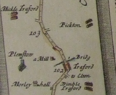
Ogilby’s Map of 1675
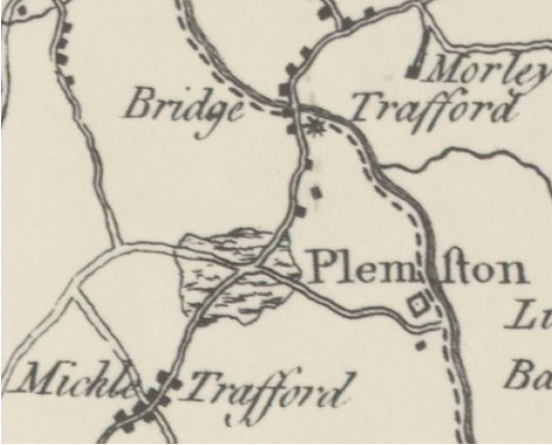
Burdette’s Map of 1777
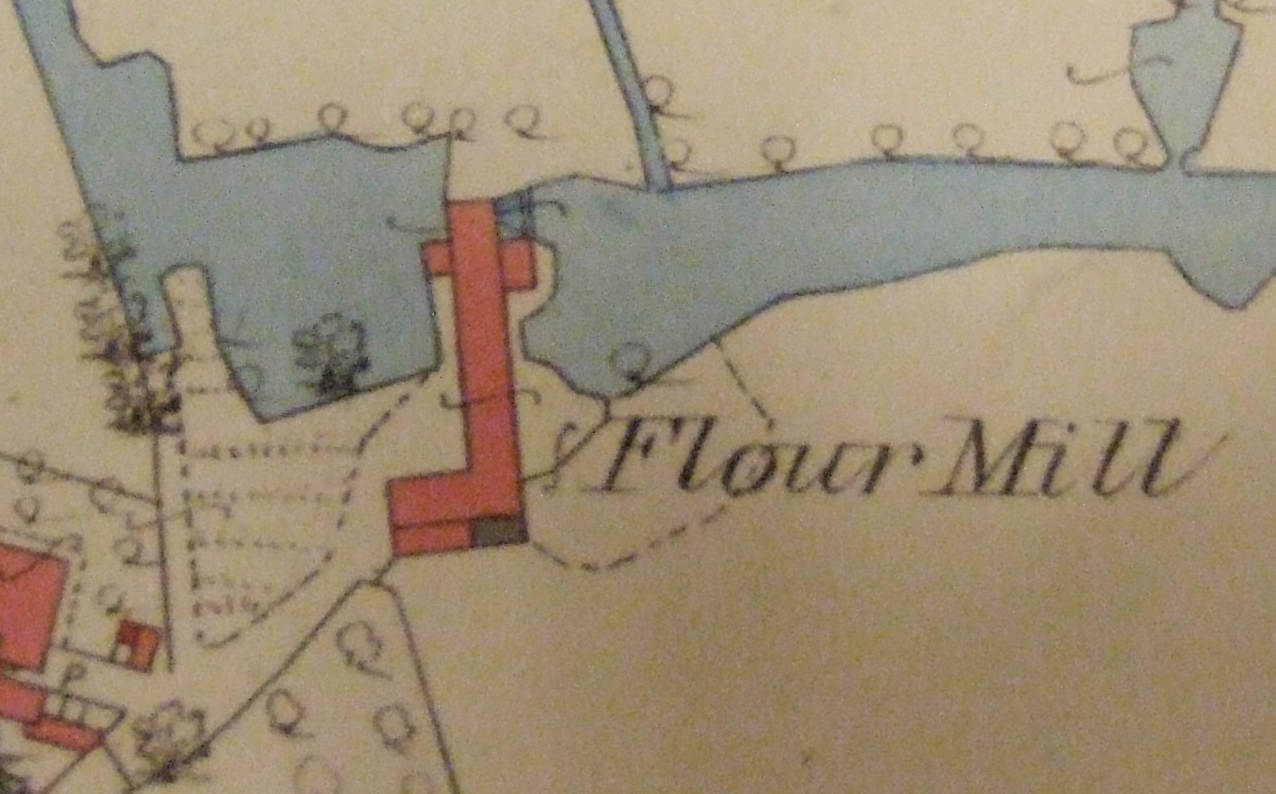
The 1777 map of the area by Burdette shows the Mill present on the site and the 1789 Shrewsbury Estate plan shows the Mill in some detail. The 1789 plan shows the northern section of the Mill straddling the river. The depiction of the river records the flow to a north and south wheel and the eastern projecting section to the building is in the same location as the existing grain drying kiln area. The estate map therefore suggests that the current northern section of the Mill had been built by 1789, and the presence of the building on the 1777 map suggests an even earlier date of 1777. An investigation by a milling specialist of the descriptions of the historic milling equipment at the Mill has indicated that the northern section was built between 1765 and 1777, providing further evidence for this earlier date. The Mill was presumably leased with the land that surrounded it, which would have included agricultural land, the millers being also engaged in farming. The Mill was advertised in the Macclesfield Courier on the 23rd of March 1811. The description of the farm accommodation indicates that the miller was also engaged in farming. The advertisement featured in the paper as follows,
‘All those old and well accustomed corn mills called Trafford Mills situated about four miles from the city of Chester on the road to Warrington and Manchester. There is also easy water carriage to Liverpool. The mills are in good condition and have six pairs of stones, viz., two pairs of French, one pair of Welch, two pairs of meal stones and one pair of shelling stones; two machines for dressing flour and one for meal, hoisting tackle, etc. The mills are worked by two waterwheels and have an excellent drying kiln attached, two warehouses, capable of holding two thousand measures of grain, a good stable and cow houses, with other stables for farmer & horses. There is a good house, with all available conveniences, gardens, orchard and seven acres of land of the large Cheshire measure, together with houses for the men employed at the mills. For further particulars Messrs. Clulow & Stone, Macclesfield.”

Earl Of Shrewsbury Estate Plan, 1789.
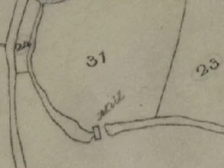
Tithe Plan of 1839
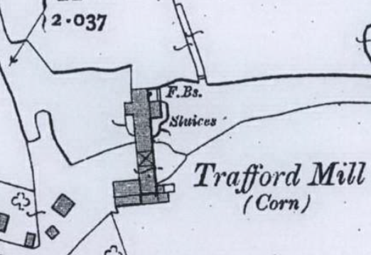
In the 1830s, the Earl of Shrewsbury undertook improvements to the estate and possibly also to the Mill. The 1839 Tithe map records the Mill, surrounded by meadowland and straddling the river, with little detail. The Tithe apportionment records Peter Slater occupying the Mill, house and land. By 1851, the census records state that William Pugh was the miller on site. The 1861 census records Rupert Fernyhough was occupying Trafford Mill and farm. When Fernyhough died in 1864, his son Frederick succeeded him and took over the farmland, which comprised 55 acres at this time. The 1881 Census returns suggest the Mill and mill farm were a sizeable undertaking with the Fernyhough household including two farm servants, a milkmaid and an assistant miller. On the wooden flour hopper located inside the existing mill building, the name ‘J. Fernyhough 1883’ is carved together with the initials ‘J.R.’ and ‘J.F’. The 1873 OS map records the Mill building in its present form with the cart shed, stables and shippon adjoining the driftway on the south side, the eastern drying kiln and the small office on the west side at the north end. In 1893 James Owen, a corn chandler, became tenant of the Mill, and by 1895, Jas. Owen was recorded as leasing the Mill, house and 33 acres, 1 rood and four perches of land at Mickle Trafford. Two years later, in 1897, Griffiths Bros., Corn Chandlers of Chester, became tenants of the Mill and Charles Wright of Picton took on the tenancy of Trafford Mill Farm, which then comprised 35 acres. Albert Michael Tourle started work for James Owen at Trafford Mill, at the age of 20. Tourle worked at the Mill when it changed hands and for the rest of his life. Albert Tourle was the last miller on site when it finally closed for business in 1950s. Information provided by Albert Tourle’s daughter indicates that in the late 19th century the mill ground maize and oats and concentrated mainly on producing animal feed
Ordnance Survey Plan, 1893.
Ordnance Survey Plan, 1910.
Although the Mill produced animal feed, the small wheel at the north end continued to be used for fine flour production until demand ceased during WWI. There appears to be little change on site over the past one hundred years, as indicated by the 1910 OS plan. In December 1917, the Chester Estates of the Earl of Shrewsbury, were auctioned. Trafford Mill was advertised as Lot 67 and described as follows:
“Trafford Water Powered Corn Mill situated on the River Gowy, about one mile north of the two railway stations at Mickle Trafford and covering an area of .175 acres. The three floored mill is constructed of brick and includes two undershot waterwheels, one out of repair and an office and the following buildings Drying Kiln, barn, three stall stable and loft over. There is also a brick and slated four roomed cottage with weighbridge, garden, pigsty and fowl house.”
In 1952, the mill lost the use of its waterwheel, when some of the paddles had to be removed to release a young boy who had fallen into the wheelpit whilst swimming. The Mill was subsequently sold to Cheshire River Board in 1954, in order to develop a system of river improvements begun by Italian Prisoners of War. Work was carried out to lower the water level of the river Gowy, with the installation of a new guillotine sluice and the construction of an earth dam between the course of the river and the original mill pond, resulted in the mill being deprived of a working water supply by the early 1960s. The mill was used to store cattle fodder until it became the property of North West Water Authority, in the implementation of the 1973 Water Act. Substantial work was carried out in the 1970s to try and improve the condition of the building.
The above content was taken from an assessment provided by Castlering Archaeology.
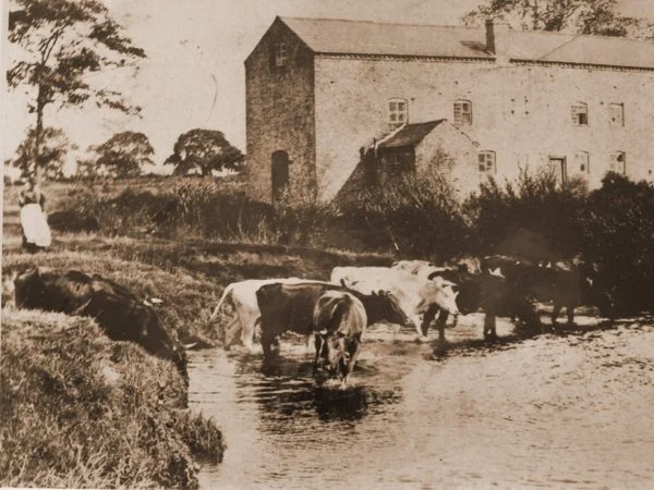
Mickle Trafford Mill Circa 1910

Mickle Trafford Mill Circa 1970